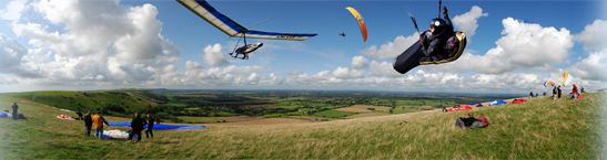
| Flight details: | I flew at Milk Hill White Horse on Sunday, but didn't enjoy it -- it was too windy, and the furthest I went was from the shoulder over the back, into the bowl and down to the bottom. However, I'd like to think that my pre-flight briefing to Mark Watts helped him break the British record that day (the briefing went like this: "Good luck, Mark.").
On Monday we mortals hoped for a mortal-friendly day. The direction suggested the bowl rather than the horse; Rybury was even pondered, but there was enough south to justify the choice of the many who gathered.
If it wasn't howling like Sunday, it wasn't un-windy either. But enough height was soon available for us to spread out a bit. Joe Crutchley was the first to go, not very high, and a few others followed. We searched for climbs out front, but they drifted quickly. After a few false starts I just missed joining a gaggle of three, but found something else, or perhaps the bottom end of their climb, and decided to commit to it, preferring the chance of a three-kilometre walk back rather than nothing at all -- the day was forecast to suffer from spreadout and stop working quite early.
I dribbled along at about 1700 feet ASL for the first few kilometres, looking enviously up at the mini-gaggle a thousand feet above me -- but I've left Milk Hill low before and survived, so I didn't give up hope. And sure enough, just in time I found a boomer that took me up to 4,500.
Soon after that I saw a UP shooting back upwind underneath me -- forgotten his sandwiches, I guessed. In fact, it was Ken Wilkinson, who didn't like the look of the weather ahead. And I found out why: suddenly too much height, not too little, was my problem. Dark clouds stretched for miles across my track. My first brush with them was sorted with one big ear and opposite 360s, but the second lasted uncomfortably long, despite big ears and full bar. With no sunny patches ahead or to the side, I used my GPS to fly south-east back the way I'd come; the s |